Volume Calculation
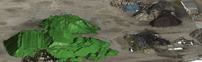
Main goal of volume calculation is to find out a volume of material that was mined or heaped up in predefined area and to verify if the volume corresponds to the expected value stated in project documentation. The volume is determined by a difference of topographies from two survey phases or by a difference between the survey and the project documentation. It is possible to measure even mounds of fine and loose materials or dangerous, difficult-to-access objects in very accurate way. High measurement speed is an indisputable advantage.
Volume Calculation – Main Fields of Application
- groundwork
- disposal area management
- material transfer
- surface mining
There are several methods of volume calculation. The easiest one is based on digital terrain / surface models (DTM / DSM). Data obtained by aerial photography or terrestrial scanning are used to create digital terrain / surface models. Thanks to the complex survey with significant number of points, final 3D models are minimally generalised and therefore calculated volume reflects the real state better than in the case of using total station or GNSS.
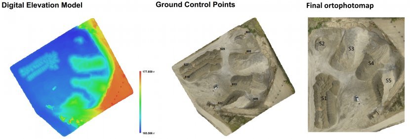 Customer receives numeric outputs concerning changes of volume capacities in concerned area or object and graphic outputs, such as basic quarry map and map of the difference. If aerial photography is used to get data for volume calculation a detailed orthophotomap is also included.
Advantages of Volume Calculation Based on Aerial Photography
- quick data acquisition
- suitable for large areas
- contactless method
Advantages of Volume Calculation Using Terrestrial Laser Scanning
- quick data acquisition
- high survey accuracy (up to 0.1 m³)
- independent on weather conditions
- contactless method