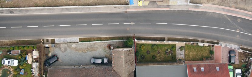
Aerial photogrammetry from planes and UAVs (Unmanned Aerial Vehicles) ensures fast and contactless acquisition of geographic data. Aerial photogrammetry is suitable especially for surveying of vast areas or buildings. The fact that simplification (generalisation) of surface is not a part of the process is a great benefit of this method.
Outputs are comprehensible and easy-to-take-in even for non-professionals, which is a big advantage of aerial photogrammetry along with a possibility to survey dangerous and hard accessible locations, such as strip mines, dumps of chemicals, tailing ponds, etc. It is also possible to obtain information about changes of concerned objects in time by repeated aerial photography.
Aerial Photogrammetry – Practical Use
Vertical aerial photogrammetry provides a basis for one of the best known and very favourite products – orthophotomap. It is also possible to create many other outputs based on aerial photogrammetry – for example a digital terrain/surface model (DTM / DSM), a purpose map, a basis for cubic capacity calculation or a contour map. All photogrammetric aerial images can be transformed into the international coordinate system WGS-84 or into the Czech national coordinate system S-JTSK.
Aerial Photogrammetry – Execution
Aerial photogrammetry technical implementation requires careful preparation. Required detail level of the final aerial survey photos or other product that is about to be obtained is a crucial factor. That is why one of main input parameters for aerial photogrammetry planning is the resolution of photos, most commonly defined as ground pixel size.
In case of the aerial photography taken from the conventional plane, which is reasonable for areas larger than 20 km², we are able to reach the resolution up to 4 cm per pixel. For areas smaller than 20 km² it is more cost-effective to use UAV that is capable of reaching the resolution up to 0.5 cm per pixel.
Technical Parameters of our Cameras for Aerial Photography
- resolution – 16 megapixels
- sensor dimensions – 23.6 × 15.7 mm
- sensor type – CMOS
- lenses
- focal length 18.3 mm (28.0 mm eqiv.), lens speed f/2.8
- output formats – RAW, JPG, TIF
- resolution – 16 megapixels
- sensor dimensions – 17.3 × 13.0 mm
- sensor type – CMOS
- lenses
- focal length 12.0 mm (25.0 mm eqiv.), lens speed f/2.0
- output formats – RAW, JPG, TIF