Documenting objects from a bird’s-eye view provides a unique opportunity to examine and monitor technical structures, historical monuments, construction progress, archaeological sites, or real estate — offering significantly greater informational value than ground-based recordings. Using our unmanned aerial vehicles, we perform the following types of inspection flights:
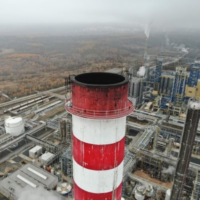
- Visible-spectrum imaging – monitoring the condition of chimneys, high-voltage pylons, wind turbines, rock weathering, and more
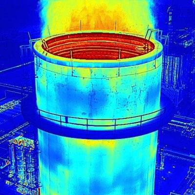
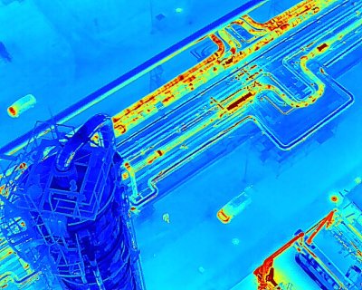
- Thermal imaging – inspection of solar power plants, detection of heat leaks from buildings or hot-water pipelines
- Multispectral imaging – evaluation of soil quality and vegetation condition, archaeological landscape surveys
- Indoor inspections – examination of interior building structures (roof constructions, collectors) and enclosed spaces using a special anti-collision drone
We have been carrying out UAV operations and aerial photography since 2009. We hold European licenses in categories A1, A2, and A3, and we have extensive experience obtaining the necessary permits for specific operations in densely populated areas and no-fly zones. We coordinate flights with all relevant authorities, and our drones are fully insured. In addition to drone services, we also provide manned aerial photography using small airplanes and helicopters.
Your eyes high in the sky
We equip our drones with various types of sensors, the most common being a full-frame camera with a 45-megapixel resolution. Using this, we can document roofs, chimneys, transmitters, and other tall structures, whose inspection would otherwise be demanding and pose a significant risk to personnel. The output doesn’t have to be just photographs — it can also be a detailed 3D model of the object’s actual condition or technical drawings recording all defects and cracks.
For inspections of enclosed spaces and interior structures, we use a special anti-collision drone.
Detect heat leaks
Using our thermal camera (with a temperature resolution of 0.1 °C) mounted on an unmanned aerial vehicle, we carry out inspections of buildings and technical facilities to detect heat leaks and other defects. The results of these inspections include 2D images, videos, or orthophoto maps. The thermal map can also be displayed on a 3D model of your building or technology.
We also capture agricultural areas, recording the thermal radiation of plants and animals.
Detect roof defects and water damage
Through thermal mapping, we detect insulation defects and water leaks, primarily on flat roofs of industrial, storage, and commercial buildings. We also inspect photovoltaic panels and similar installations.
We provide unmanned aerial imaging and perform subsequent processing into orthophoto maps or technical drawings, including marked defect locations. All results are delivered in a custom online environment for easy viewing and sharing.
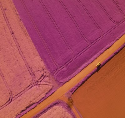
Precision agriculture and archaeology
With our unmanned aerial vehicles, we also collect data to evaluate soil quality, crop conditions, and vegetation changes over time. For this, we use a four-channel camera with four separate sensors to capture light in four wavelength bands:
- Green light (510–550 nm)
- Red light (620–760 nm)
- Red edge (690–730 nm)
- Near-infrared (NIR) (760–1,400 nm)
By measuring the reflectance of light from plant leaves, we can determine the amount of chlorophyll they contain. This value allows us to assess plant health as well as secondary indicators such as soil quality or current moisture levels. This provides essential data for precision agriculture. The imaging is also used to monitor vegetation signals in archaeological surveys.